On 24 October 2025, the CLIMAAX–Crete team shared new insights on flood risk and extreme precipitation at the SAFEHERAKLION 2025 International Conference on Civil Protection in Heraklion. The presentation introduced a Crete-wide flood hazard and risk assessment developed through standardised CLIMAAX workflows and enhanced with locally refined data.
The team combined high-resolution flood hazard maps for ten flood-prone areas with exposure and vulnerability layers, including building footprints and land-use classes. This integration enabled detailed estimates of potential damage and people-at-risk metrics.
Across the island, Heraklion consistently emerged as a hotspot, with additional critical areas identified in Messara and Northern Chania.
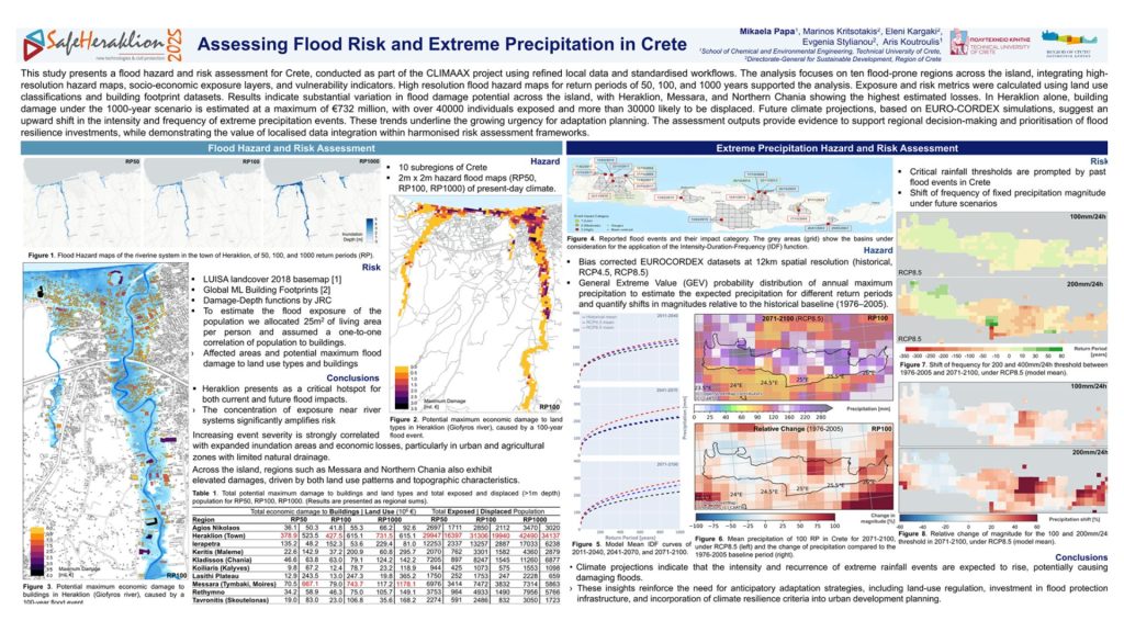
To explore climate-driven shifts, researchers analysed EURO-CORDEX daily precipitation data, applying GEV distributions to annual maxima. The results point to an upward shift in intensity–duration–frequency curves, signalling more frequent high-intensity storms. These changes are expected to shorten return periods for damaging events and increase flood risks for both urban centres and agricultural landscapes.
The findings underscore the importance of anticipatory adaptation, including land-use regulation, drainage upgrades, and strategic flood-protection investments. The team also emphasised data sharing, transparent methodologies, and clear implementation pathways—cornerstones of the CLIMAAX approach.
Developed jointly by the Technical University of Crete and the Region of Crete, this work demonstrates how localised, high-resolution evidence, embedded within a harmonised European framework, can directly support regional planning.
The session highlighted how Greek regions can use CLIMAAX results to align risk assessments with investment pipelines and inform upcoming policy updates.